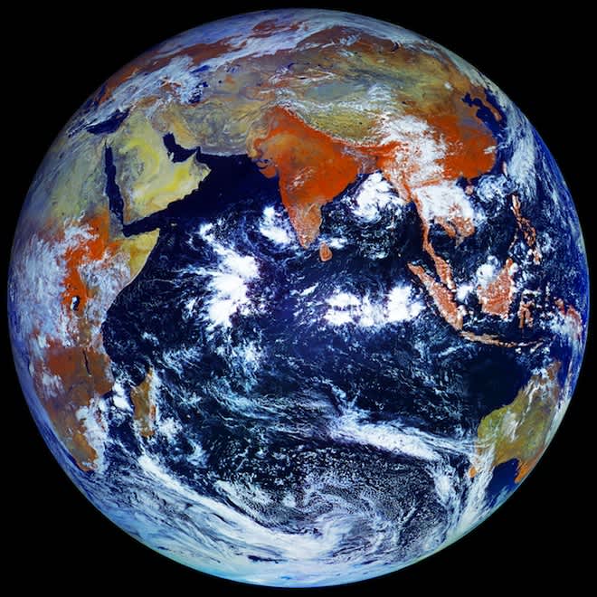
Russian Satellite Captures Largest Image of Earth to Date
OutdoorHub Reporters 05.14.12


Even though the Cold War’s over, there’s still a little bit of extraterrestrial competition between the United States and Russia. So when NASA published the most accurate, highest resolution photograph of Earth a decade ago called “Blue Marble”, it’s only natural that the Russians would follow suit with their own even-higher resolution image seen above. The picture was taken by a recently-launched Russian weather satellite called the Elektro-L.
NASA’s Blue Marble is made from a composite of images taken at different times. The Russian image is a single shot. To date, it is the highest resolution image of Earth at 121 megapixels in size. Each individual pixel measures out to 0.62 miles.
The Elektro-L orbits earth from a geostationary orbit 36,000 kilometers (22,370 miles) above the equator, taking a snapshot of our home planet every 30 minutes and transmitting it back to ground control. It was launched January 20, 2011 from the Baikonur Cosmodrome in Kazakhstan on board a Zenit rocket. This was one of the first spacecraft fully developed in post-Soviet Russia.
The images and time-lapse video were processed by University of Victoria student James Drake. The images are “a combination of visible and near-infrared wavelengths, so they show the Earth in a way not visible to human eyes,” according to an interview with a NASA scientist with Gizmodo. The combination of different light wavelengths is also why vegetation appears to be red in the images.
Watch the time-lapse video from the satellite taken between May 14th and May 20th, 2011. It’s interesting to note the sun the never sets on the tip of the Arctic at this time of year.
httpv://youtu.be/6twFHqJ03_k

